I fought with my nearly 2-year-old to get her into multiple layers of clothing Saturday before leaving the house to attend an event. Down here in Alabama, we saw patches of ice on bridges, salted roadways, a little bit of snow that didn't stick and a chunk of ice in the backyard that formed from a puddle during Winter Storm Fern the weekend of Jan. 23 that has yet to melt.
Fern, a storm that for some areas was the worst in over a decade, marked the most significant and widespread winter weather event this season, followed closely by Winter Storm Gianna, which has been referred to as a "bomb cyclone." I've never heard of a bomb cyclone so off to Google I went to learn that it's a storm that undergoes bombogenesis. I'll leave the Googling and understanding of bombogenesis to you.
After all that, the groundhog told us Monday that we have six more weeks of winter, while tens of thousands of residents remained without power following Gianna, which has moved out but left behind reports of dangerous roadways, according to The Weather Channel.
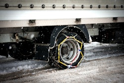
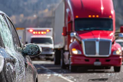
The impact of winter weather on roadways is clear based on the data.
Geotab’s real-time connected vehicle data recorded a 53% spike in collisions nationwide during the weekend of Fern compared to the previous two weekends (Jan. 10-11 and Jan. 17-18) of what was considered "normal" weather. Gianna this past weekend ramped up that number even higher to 84% compared to the same "normal" weekends.
Geotab vice president of data and AI Mike Branch said this data reflects ongoing hazardous driving conditions, including lingering ice, snow buildup and reduced visibility, which remain even after storm systems move through.
“Our data strongly indicates that the majority of this 53% spike is directly tied to the deteriorating road conditions from Winter Storm Fern,” Branch said. “To ensure accuracy, we benchmarked this activity against the previous two weekends, where we typically see very similar driving patterns amongst fleets, and the correlation between the winter storm and the surge was undeniable.”

That’s why real-time weather intelligence is paramount for fleets.
Branch said it allows fleet managers to move from reacting to weather impacts to actively managing risk as conditions change. Hyper-localized weather intelligence – in some cases down to the name of the road a driver is routed on – provides even greater insight that isn't available in a general weather report.
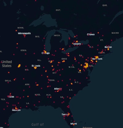
According to the data, regional hotspots – or areas with the highest collision rates – during Fern included Maryland, Kentucky and Indiana. During Gianna, Texas was the leading hotspot, followed by North Carolina.
Though I'm no expert, I would venture to guess that significant jump in collisions the weekend of Fern versus the weekend of Gianna could have to do with Gianna's concentration on southern states that lack the resources to manage ice and snow on roadways.
“The regional hotspots show how quickly localized weather events can translate into elevated collision risk for fleets. Areas like Maryland and parts of the Mid-Atlantic and Midwest are major freight and commuter corridors, so when winter weather hits, even brief periods of snow or ice can have an outsized impact,” Branch said. “These hotspots help us identify where exposure is highest and reinforce that risk is highly regional. Fleets can’t rely on broad forecasts alone and need localized, real-time visibility to adjust operations.”
Geotab monitors vehicle location, speed, harsh braking, stability control events and sudden changes in driving behavior that often signal deteriorating road conditions.
In practice, Branch said fleets use this data to reroute vehicles away from high-risk areas, adjust delivery schedules, lower speed thresholds and proactively coach drivers when they see early indicators of hazardous conditions, helping reduce exposure during the most dangerous periods of a storm and improve overall driver safety.
From a safety and operational perspective, I'm unsure how any carrier at this point doesn't use real-time weather intelligence from one of the several providers in the market. The money spent to subscribe to such platforms would have to be minuscule compared to the amount saved from a reduction in accidents and an increase in operational efficiency.